About HiiKER: The Hiking Maps App
Find the best hiking trails near you and navigate offline. Choose from our range of premium topo maps such as USGS, US forestry maps, National parks and many more in 3D. HiiKER is the hiking app that is dedicated to...
Find the best hiking trails near you and navigate offline. Choose from our range of premium topo maps such as USGS, US forestry maps, National parks and many more in 3D.
HiiKER is the hiking app that is dedicated to building tools specifically for the hiking community. More than just a map and a compass, the app enables you to hike in the great outdoors with confidence, now with free offline maps.
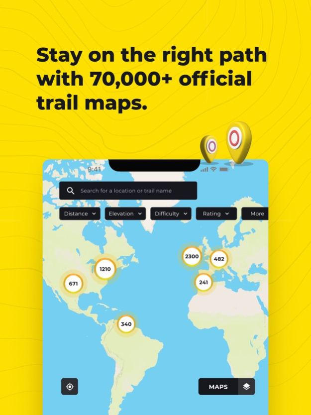
Discover thousands of Hiking trails
With HiiKER, you can discover one of over 90,000 of the world’s best hiking, thruhiking, walking and backpacking trails right from your smartphone. Looking for the perfect Family hike? Or want to take the dog out on a walk in nature?
Maybe you’re planning a multi-day hiking adventure. Or you're looking for one of those spectacular Lake District Hikes you’ve heard about. You’ll find the trail that’s right for you with our powerful search tool. All trails are available to download offline while in the mountains.
Plan Ahead
You’ll find thousands of accommodation and amenity options for your adventures. Plan ahead with the perfect lunch spot, campsite, resupply town or maybe even a 5-star hotel on your hiking trip.
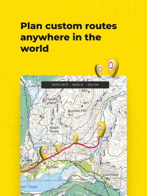
Create your own custom trail
The HiiKER Trail Planner will enable you to blaze your own trail and plan a custom hike. You can share all trails with your adventure crew so that everyone is prepared for the hike.
Import GPX files
Got a GPX file of an awesome hiking trail from a friend or other source? Import it to HiiKER and make your own edits to the route before hitting the trail.
Track your Hikes
The HiiKER GPS Tracker records your hiking activity and gives you in-depth detail about your walks that you can share with your adventure crew. Got an ultra run you want to record? HiiKER has you covered. Forgot your compass? Let HiiKER be your compass and get your bearings with our intelligent maps.
High-Resolution Map layers
We are building the most comprehensive selection of free map layers available. You'll find the layer that is best suited to your hike. These maps include
Thunderforest
Open street maps
Satellite
Nature
IGN France
USGS
Get Lost
Offline Maps
With HiiKER PRO you can download all your favourite hiking trails to your phone to use offline - even in airplane mode. This is perfect for those hiking adventures where cell service is not guaranteed. It is also much less intensive on your battery life, meaning you can use it for longer!
Heading out on the End to End Trail? Or the West Highland Way? Maybe you’re bagging Munros or Wainwrights. Save the map to your device to make sure you’ll always have it when you need it.
Measure the Distance
While exploring the map, use our handy measurement tool to know what distance, terrain and elevation lie ahead on your hiking trail. This gets you ready for any change in elevation gain/loss and allows you to know how much time the section of the hiking trail will take.
GPX Download
Export GPX files of one of the thousands of hiking trails on HiiKER. Sync them with your other gps devices, such as Garmin Smartwatches, Garmin navigation devices, Coros watches, Suunto watches and many other navigation devices that support GPX, KML and GEOJSON files.
Print trail maps
Get that compass out and always make sure you have a backup by printing our high-resolution PDF trail maps
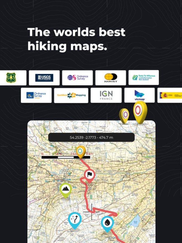
Premium High-Resolution maps
With HiiKER PRO+, you get access to some of the world's best map makers in the world on the platform. These high-resolution maps include
OS Maps
Harvey Maps
Ordnance Survey Ireland
EastWest Mapping
USGS
TASMAP
Get lost
Vicmap
LINZ
All of these maps can be used in conjunction with other HiiKER features.
Quality Data
We partner with trail organisations, such as the Bibulmunn Track, The Te Araroa, The Larapinta trail, The Pacific Crest Trail, The South west Coast Path and National parks and other trusted sources around the world to bring you the most up-to-date and official trail data available.
Contact us at
[email protected]
Legal
Terms of Service: https://hiiker.app/terms-of-service
Apr 16, 2024
Version 5.006
Exciting Map Updates Await You!
We're thrilled to announce a major overhaul in how you experience maps on HiiKER, making your adventures even more seamless and enjoyable. With a simple, single click, you can now effortlessly switch between the finest maps available, streamlining your navigation experience. This significant enhancement reduces complexity and is a game-changer, especially when you're exploring the great outdoors!
Introducing 3D Maps!
For the first time on HiiKER, embark on a breathtaking journey with our new 3D maps. Explore every trail and map in stunning 3D, bringing your outdoor adventures to life like never before. Plus, enjoy an exclusive feature to HiiKER - 3D topo maps from our esteemed premium mapping partners, including Ordnance Survey, Harvey Maps, EastWest Mapping, OSi, OSNi, USGS, IGN, Swiss topo, and many more.
Performance Boosts & More
This update isn't just about looks; it significantly enhances the app's performance, reliability, battery optimization, and load speed. We've worked tirelessly to ensure that your experience is smoother and more efficient.
Simplified Trail Downloads
Downloading trails for offline use has never been easier. With just a tap on the map style of your choice, you can make any trail available for offline access, ensuring you're always ready for your next adventure.
Dive into the new version of HiiKER today and see how we're making your outdoor experiences more exciting and effortless. Happy hiking!
5.006 - Updates to planning and recording pages
Previous Versions
Here you can find the changelog of HiiKER: The Hiking Maps App since it was posted on our website on 2021-12-17 08:56:18.
The latest version is 5.006 and it was updated on 2024-04-22 09:20:55. See below the changes in each version.
HiiKER: The Hiking Maps App version 5.006
Updated At: 2024-04-16
Changes: Apr 16, 2024
Version 5.006
Exciting Map Updates Await You!
We're thrilled to announce a major overhaul in how you experience maps on HiiKER, making your adventures even more seamless and enjoyable. With a simple, single click, you can now effortlessly switch between the finest maps available, streamlining your navigation experience. This significant enhancement reduces complexity and is a game-changer, especially when you're exploring the great outdoors!
Introducing 3D Maps!
For the first time on HiiKER, embark on a breathtaking journey with our new 3D maps. Explore every trail and map in stunning 3D, bringing your outdoor adventures to life like never before. Plus, enjoy an exclusive feature to HiiKER - 3D topo maps from our esteemed premium mapping partners, including Ordnance Survey, Harvey Maps, EastWest Mapping, OSi, OSNi, USGS, IGN, Swiss topo, and many more.
Performance Boosts & More
This update isn't just about looks; it significantly enhances the app's performance, reliability, battery optimization, and load speed. We've worked tirelessly to ensure that your experience is smoother and more efficient.
Simplified Trail Downloads
Downloading trails for offline use has never been easier. With just a tap on the map style of your choice, you can make any trail available for offline access, ensuring you're always ready for your next adventure.
Dive into the new version of HiiKER today and see how we're making your outdoor experiences more exciting and effortless. Happy hiking!
5.006 - Updates to planning and recording pages
HiiKER: The Hiking Maps App version 5.003
Updated At: 2024-03-25
Changes: Mar 25, 2024
Version 5.003
Exciting Map Updates Await You!
We're thrilled to announce a major overhaul in how you experience maps on HiiKER, making your adventures even more seamless and enjoyable. With a simple, single click, you can now effortlessly switch between the finest maps available, streamlining your navigation experience. This significant enhancement reduces complexity and is a game-changer, especially when you're exploring the great outdoors!
Introducing 3D Maps!
For the first time on HiiKER, embark on a breathtaking journey with our new 3D maps. Explore every trail and map in stunning 3D, bringing your outdoor adventures to life like never before. Plus, enjoy an exclusive feature to HiiKER - 3D topo maps from our esteemed premium mapping partners, including Ordnance Survey, Harvey Maps, EastWest Mapping, OSi, OSNi, USGS, IGN, Swiss topo, and many more.
Performance Boosts & More
This update isn't just about looks; it significantly enhances the app's performance, reliability, battery optimization, and load speed. We've worked tirelessly to ensure that your experience is smoother and more efficient.
Simplified Trail Downloads
Downloading trails for offline use has never been easier. With just a tap on the map style of your choice, you can make any trail available for offline access, ensuring you're always ready for your next adventure.
Dive into the new version of HiiKER today and see how we're making your outdoor experiences more exciting and effortless. Happy hiking!
5.003 - Minor Bug fixes
HiiKER: The Hiking Maps App version 4.012
Updated At: 2024-01-31
Changes: Jan 31, 2024
Version 4.012
There was an issue with our trail stages feature that was causing a small number of crashes.
HiiKER: The Hiking Maps App version 4.010
Updated At: 2024-01-25
Changes: Jan 25, 2024
Version 4.010
We have improved our interface to make the use of the app more simple and got rid of some pesky bugs!
HiiKER: The Hiking Maps App version 4.009
Updated At: 2024-01-09
Changes: Jan 9, 2024
Version 4.009
New Feature! Add a waypoint when you "Go to location". Add a grid reference/Lat-lon, then navigate to that point! Minor bug fixes.
HiiKER: The Hiking Maps App version 4.008
Updated At: 2024-01-06
Changes: Jan 6, 2024
Version 4.008
App is now faster at loading and more battery efficient. Fix for crash on Go To Location. Improvement to the handling of network status.
HiiKER: The Hiking Maps App version 4.005
Updated At: 2023-12-29
Changes: Dec 29, 2023
Version 4.005
Bug fixes and minor updates.
HiiKER: The Hiking Maps App version 4.004
Updated At: 2023-12-18
Changes: Dec 18, 2023
Version 4.004
Bug fixes
HiiKER: The Hiking Maps App version 4.003
Updated At: 2023-12-11
Changes: Dec 11, 2023
Version 4.003
We have made major branding and interface changes to the app. With this more minimal branding, we have made using the app even more simple and user-friendly.
HiiKER: The Hiking Maps App version 4.002
Updated At: 2023-11-27
Changes: Nov 27, 2023
Version 4.002
We have made major branding and interface changes to the app. With this more minimal branding, we have made using the app even more simple and user-friendly.